By Julia Maron
Julia Maron is a Research Technician with the UNC Institute for the Environment
Is there a connection between wildfire occurrence and debris flows (landslides) within that previously burned area? University researchers in partnership with state and federal officials are working to answer that question in North Carolina.
Recent Landslide Activity in North Carolina
After 5 people were killed by landslides in Macon County in 2004, the state commissioned the North Carolina Geological Survey (NCGS) to create landslide hazard maps for the 19 western mountain counties. These maps combine a stability index with past slope movements, debris flow pathways, and areas of potential rock slope instability.
The goal was to show which areas had potential to slide and ultimately prevent future injuries and deaths. But the program was defunded in 2011 and only Macon, Watauga, Buncombe, and Henderson counties had mapping completed. After 7 years and several additional losses of life and property, $3.6 million has been appropriated to NCGS to resume mapping the rest of the counties.
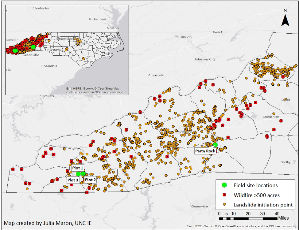
Debris flows, colloquially known as landslides, are moving masses of loose material, at least half of which is bigger than the size of sand. For a debris flow to occur, an area must have a steep slope, loose debris, a source of abundant moisture, and only sparse vegetation holding everything in place. Debris flows also tend to occur where they have previously happened.
Connection of Landslides and Wildfires?
Most individuals who live in the mountains are unaware that their property may be in a landslide-prone area. Many have lived there for years and have not known or been informed about the risk. State law doesn’t require owners to be informed of landslide hazards nor is there such a thing as “landslide insurance” in case one destroys your property. Increases in development, roads, and logging, along with more frequent and intense rainfall, contribute to greater landslide impacts on people and property.
Not only has western NC recently seen deadly landslides, but there have also been several major wildfires and even more minor ones:
- In 2016, the Party Rock fire burned about 8,500 acres over the course of 3 weeks in the populated town of Lake Lure near Chimney Rock.
- The Camp Branch fire on Wayah Bald in Macon County burned around the same time and scorched 3,200 acres.
We visited these sites this spring to see what the post-fire landscape looks like after more than 2 years.
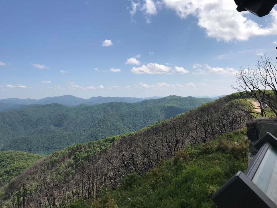
Naturally occurring wildfires can benefit the environment by returning nutrients to the soil, allowing seedlings to get sunlight, and removing harmful insects and diseased plants. However, when they threaten life and property and require extensive efforts to control, they can be life-threatening and devastating.
Our team from the UNC Institute for the Environment, North Carolina Geological Survey, U.S. Forest Service Southern Research Station, and Appalachian Landslide Consultants, are examining several different factors that may tell us whether there is a relationship between wildfires and landslides, such as:
- percent of organic matter in the soil;
- hydrophobicity of the soil;
- vegetation;
- the geological makeup of the area; and
- the slope.
So far, we have visited two recently burned sites (Party Rock and Wayah Bald) to gather some of this data. We also briefly looked at a large landslide that occurred in June 2018 across NC Highway 9.
Upon first impression, one would think an area that has burned and is subsequently devoid of healthy trees and vegetation would be more prone to a landslide after it rains. Our project is designed to explore that link and see if the data supports our initial impression.
Once the project is completed, we’ll share the results with state policy-makers and work to identify potential management actions that could mitigate future landslides.
This project is supported with funds from the North Carolina General Assembly and managed by the North Carolina Policy Collaboratory.